Cambridge climate |
Cambridge is 52 deg 12 North and 0 deg 07 East. This means that it is nearly on the Greenwich meridian. England has a temperate maritime climate, because of its distance from the equator and its closeness to the Atlantic Ocean. We are lucky to have the Gulf Stream, a warm ocean current which starts from the Caribbean, and sweeps across the Atlantic and up the west coasts of Ireland and Scotland. It is interesting to compare Cambridge's climate to those of other places on the same latitude (or distance from the equator). The following data comes from www.worldclimate.com. They are coloured according to whether they are on the eastern or western seaboard, or mid-continent, or southern hemisphere.
| Location | Lat/Long | Temperature (deg C) | Rainfall (mm) | |||
|---|---|---|---|---|---|---|
| Coldest month | Hottest month | Driest month | Wettest month | Year | ||
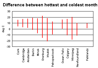
| Cork, Ireland | 51N 8W | 5.1 (Feb) | 15.0 (Jul) | 61.9 (Jun) | 127.3 (Dec) | 1081.2 |
| Cambridge, England | 52N 0E | 3.4 (Jan) | 16.6 (Jul) | 30.9 (Feb) | 59.8 (Jul) | 552.4 |
| Amsterdam, Netherlands | 52N 4E | 2.5 (Feb) | 17.1 (Jul) | 39.3 (Apr) | 103.7 (Oct) | 831.6 |
| Berlin, Germany | 52N 13E | -0.9 (Jan) | 18.6 (Jul) | 37.6 (Feb) | 71.1 (Jul) | 588.7 |
| Minsk, Belarus | 53N 27E | -6.9 (Jan) | 17.4 (Jul) | 37.7 (Feb) | 88.3 (Jul) | 678.3 |
| Orenburg, West Russia | 51N 55E | -14.6 (Jan) | 21.8 (Jul) | 18.5 (Feb) | 42.9 (Jun) | 361.5 |
| Irkutsk, Mid Russia | 52N 104E | -20.4 (Jan) | 17.9 (Jul) | 8.2 (Feb) | 96.2 (Jul) | 419.8 |
| Petropavlovsk, Kamcatski, East Russia | 53N 158E | -8.6 (Jan) | 12.4 (Aug) | 45.5 (Apr) | 90.2 (Aug) | 792.8 |
| Ocean Falls, West Canada | 52N 128W | 0.9 (Jan) | 15.7 (Jul) | 168.0 (Jul) | 562.1 (Dec) | 4390.7 |
| Calgary, Alberta, Canada | 51N 114W | -10.2 (Jan) | 16.4 (Jul) | 13.8 (Jan) | 81.6 (Jun) | 421.2 |
| Winnipeg, Manitoba, Canada | 49N 97W | -17.4 (Jan) | 20.2 (Jul) | 15.9 (Feb) | 82.0 (Jun) | 542.3 |
| Newfoundland, East Canada | 52N 55W | -10.5 (Jan) | 9.9 (Aug) | 49.7 (Jan) | 87.8 (Aug) | 865.2 |
| Falkland Islands | 52S 58W | 2.0 (Jul) | 9.3 (Feb) | 47.1 (Aug) | 71.6 (Jan) | 642.6 |
The Falkland Islands are in the Southern hemisphere, so their seasons are reversed. There are no other southern locations given, since Cambridge is further from the equator than anywhere in Africa, Australia and New Zealand.
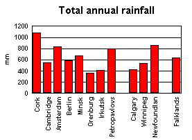
Rainfall is more erratic than temperature, but the centre of continents seem to be drier than the edges. Cambridge is an exception to this. Its total rainfall is closer to Germany than Ireland or Netherlands, its neighbours.
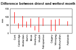
When you look at the wettest and driest months, this becomes more noticeable. Cambridge has a more even spread of rainfall throughout the year, so although there are several places with less rain in their driest month, only one has less rainfall in its wettest month.
Cambridge is on the east of England, and is extremely flat. Rain coming from the Atlantic has to pass over Ireland and Wales (which has mountains). Cambridge is one of the driest places in UK. However, it is in the middle of fertile farmland, and still has the occasional flood!